blank

Hartfield in East Sussex

Google map showing area surrounding Hartfield
(A.A.Milne and Winnie-the-Pooh)
Location: 51.102295,0.111502
General Details
St Mary the Virgin church (Hartfield East Sussex)The village is named in the Domesday Book of 1086 , but the present church was not started until the 1250's .

The village grew from its agricultural roots until it became a centre for iron and timber . The village had a furnace and forge in the valley to the north, producing iron goods . The wealth from the iron can be seen from the construction of the church and the buildings in the village. A most unusual black and white timbered house lies at the entrance to the churchyard which incorporates a lychgate .

In 1924 the village saw its main claim to fame arrive in the guise of the Milne family who bought Cotchford Farm . A small bridge was built over the stream at the end of their land in 1925 . A young Christopher Robin Milne visited the shops in the village with his nanny in the 1920's, his father A.A.Milne wrote the Winnie-the-Pooh stories which incorporated the young Christopher.( see also Guestling ). A.A.Milne died at Cotchford in 1956.

The area near Hartfield in East Sussex is also included in his books, with the bridge on the farm being the place where Poohsticks were invented.

The bridge can still be visited as it was restored by East Sussex County Council in 1979 the bridge lies to the south of the village.
Views
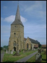
Hartfield in East Sussex has some very nice views to the north across the rolling countryside, one of the best is from the churchyard.

Lychgate cottage which lies at the entrance to the churchyard is a very pretty old building with oak used in most of its construction.

Church lane is very pretty with many old tile hung and half timbered buildings.
Services
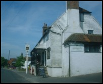
Hartfield in East Sussex has quite a few local services for a small village, this is probably due to the number of visitors who come to see the area that A.A.Milne used to live in.

The nearest main shopping centre is at East Grinstead, about 6 miles to the north west.

The nearest main line station also lies at East Grinstead , with a regular service into London.
Map
Hartfield is shown as the red symbol on the map.

Nearby Villages

(click on symbol to see the village page)
Village= Town= Recorded in Domesday=
Ashurst (Miraculous Carving)2.71 miles
Blackham (Roughs and Prize Fighters)2.69 miles
Chelwood Gate The Forest entrance and President Kennedy5.39 miles
Colemans Hatch (Church on the edge of the forest)2.21 miles
Crowborough (The home of Sir Arthur Conan Doyle)3.73 miles
Eridge Green (The home of the Neville Family)4.88 miles
Fordcombe (Paper Mill and the Field Marshal)4.06 miles
Forest Row (The Kings hunting party)3.43 miles
Groombridge (Home of the Groombridge Gang)3.33 miles
Langton Green (Modern village and Old Quarry)4.89 miles
Mark Cross (Policeman arrests eccentric landowner)7.03 miles
Rotherfield (Source of the rivers Rother and Uck)
6.12 miles
Rusthall (The Toad Rock)5.66 miles
Speldhurst (Nobleman captured at Agincourt)5.78 miles
Withyham (De La Warrs and Sackvilles)1.00 miles
Copyright Villagenet 1998-2024
 
Local Businesses
Battle Brewery our local excellent micro brewery
For all things mosaic, commissions workshops etc please contact Hannah
The Rudes as lots of people call us, are an outdoor touring theatre company specialising in taking new & original theatre to mainly small rural communities and a few towns across the South of England. We were founded in 1998 & first toured in the Summer of 1999. Currently we tour only in the summer performing 50+ times nightly during June, July & August. https://therudemechanicaltheatre.co.uk
Talk in Code fabulous new Album
The Bald Explorer for local documentaries
Tenderheart Childrens Charity